Systemic Destruction and the Limits of Data
An examination of Forensic Architecture's report on the Israeli Military in Gaza
Youssef, H.O., 2025. "Israel Leveled Gaza — Then Killed the Drone Journalists Who Showed it to the World." The Intercept
Introduction
The advent of the Big Data era brought with it a provocative epistemological promise: that with sufficient volume, velocity, and variety of data, the world would render itself transparent. Chris Anderson (2008) notably argued for an End of Theory, suggesting that massive datasets allow correlations to supersede causation, effectively letting 'data speak for itself.' However, in the realm of Urban Analytics, this positivist assumption faces a critical stress test when applied to conflict zones where the urban is not a site of growth, but a target of erasure. This essay critiques the methodologies employed in Forensic Architecture's (FA) monumental 827-page report, A Spatial Analysis of the Israeli Military's Conduct in Gaza since October 2023 (2024).
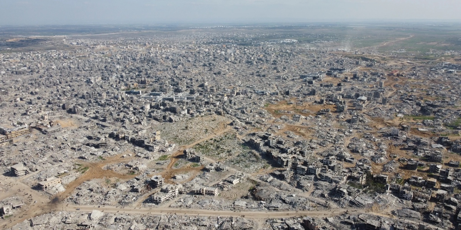
Selected not as a traditional exercise in urban planning, but as a sophisticated application of urban analytics tools—GIS, remote sensing (NDVI), and machine learning—repurposed for "counter-forensics" (Weizman, 2014)[1], the report documents the systematic destruction of the Gaza Strip. Drawing upon FA's "General Cartographic Database" (GCD), an interactive platform synthesizing thousands of verified incidents, this essay argues a dual thesis. First, that FA's methodology represents a necessary evolution of "Urban Management" into the retroactive auditing of "urbicide"—the deliberate violence against the city (Graham, 2004). Second, the essay posits that despite the methodological rigour and the sheer volume of data presented—documenting the destruction of 36% of Gaza's territory for spatial control—the case demonstrates the failure of the "End of Theory" paradigm. The report reveals that urban data, no matter how granular, cannot exist in a vacuum; it requires a theoretical framework of International Humanitarian Law (IHL) to render it legible as evidence, proving that data relies on theory to convert statistical correlation into political truth.
Re-appropriating the Urban: Analytics as Counter-Forensics
To situate this report within the domain of Urban Planning and Management requires a redefinition of what it means to "manage" a city during conflict urbanism. Traditional urban analytics utilizes Geographic Information Systems (GIS) and sensor networks to optimise flows, map zoning districts, and maintain infrastructure through predictive maintenance (Batty, 2013). Forensic Architecture inverts these identical tools. Instead of using spatial analysis to construct the urban fabric, they use it to reconstruct its systematic dismantling. This aligns with Graham's (2004) concept of "urbicide," establishing the report as an audit of destructive urban management.
This inversion is evident in the specific technical applications used in the report. Standard municipal planning employs computer vision algorithms to detect potholes for repair; FA employs similar crater detection algorithms to map the density of munitions strikes (FA, 2024, p. 309). Where urban planners use satellite imagery to monitor urban sprawl and construction, FA uses the same photogrammetric tools to map the forced morphological transformation of Gaza through demolition. Specifically, FA identifies the "Netzarim Corridor" (Route 749) not as a transport artery, but as an instrument of spatial control. Through satellite regression analysis, FA documents the clearing of a 6.5 km-long road with 2–3.5 km wide margins, effectively bisecting the strip. This represents a form of extreme, military-imposed rezoning that required the destruction of five university buildings, a courthouse, and a hospital to create a "logistical complex" of control (FA, 2024, p. 71).
Furthermore, the report quantifies the expansion of the eastern "Buffer Zone," calculating that 55 sq km (15% of Gaza) has been flattened. By treating the rubble, earth berms, and 13 identified "raid routes" as data points within a spatial grid, FA transforms the chaotic "fog of war" into a readable urban dataset. They reveal that the total area cleared for these spatial elements amounts to 131.7 sq km—36% of the total area of Gaza. This validates the relevance of the case to this assessment: it is an interrogation of the built environment through the lens of Big Data, asking not how a city functions, but how it is engineered to cease functioning.
Methodological Rigour: The Technical Limits of the "3 Vs"
The assessment of any Big Data methodology must grapple with the "3 Vs": Volume, Velocity, and Variety (Kitchin & McArdle, 2016). FA's approach to the Gaza report offers a unique case study of how these dimensions function—and fail—in a zone of infrastructural collapse. While the report excels in compiling confirmed incidents, a critical examination reveals the inherent technical limitations of "remote sensing" a conflict zone.
Velocity and the Problem of "Missing Data"
A major methodological challenge identified in the report is the "missing data" caused by telecommunications blackouts and environmental factors. FA relied heavily on NDVI (Normalised Difference Vegetation Index) analysis to calculate an 83% destruction of plant life in Gaza (FA, 2024, p. 250). NDVI works by measuring the difference between near-infrared (which vegetation reflects) and red light (which vegetation absorbs). However, this tool is notoriously susceptible to atmospheric interference. The report admits that heavy cloud cover in October 2023 and February 2024 "reduced [the] ability to conduct NDVI... for these months" (FA, 2024, p. 245). FA addressed this by using "mosaicking"—stitching together cloud-free pixels from multiple days to create a composite image. While scientifically valid, this method introduces a temporal smoothing effect; it interpolates data over time, potentially obscuring specific dates of destruction. This highlights a critical weakness: the "velocity" of satellite data is contingent on atmospheric transparency, meaning the dataset is an estimation of destruction rather than a real-time log.
Variety and Selection Bias
FA integrates "Thick Data" (testimony) with "Big Data" (satellite imagery). They utilize Open Source Intelligence (OSINT) to verify incidents, such as the destruction of the Rafah crossing (FA, 2024, p. 537). However, reliant as it is on social media footage, this methodology suffers from inherent selection bias. Incidents are more likely to be documented and verified in areas with surviving telecommunications infrastructure or electricity to charge devices. Consequently, dark zones (areas under total siege or blackout), may be underrepresented in the GCD. While the map appears comprehensive, it is essentially a map of visible violence; the absence of a data point does not confirm the absence of an atrocity, but rather the absence of a witness with a smartphone.
Algorithmic Objectivity and Machine Learning
The report employs machine learning to classify land cover, determining that 70% of Gaza's agricultural land was destroyed. This requires training an algorithm to distinguish between "arable land," "sand," and "rubble." In an environment like the Al-Mawasi "humanitarian zone," which consists largely of dunes (FA, 2024, p. 21), distinguishing between natural sand and the pulverized concrete of a bombed structure is technically fraught. The spectral signatures of concrete dust and sandy soil can overlap in multispectral imagery. While FA calibrates this with ground-level images, the reliance on algorithmic classification introduces a margin of error that is rarely present in traditional urban planning, where object classes (roads, buildings, trees) remain distinct. This technical scrutiny reveals that the "truth" presented by FA is not raw data, but a highly processed construct, distinct from the ground reality it seeks to represent.
The Epistemology of the View: Why Data Cannot "Speak for Itself"
A central debate in Critical Data Studies is the tension between the "God's eye view" (GEV)—the detached objectivity of the map—and situated knowledge (Lyon, 2014). Chris Anderson's (2008) claim that sufficient data allows relations to replace causes implies that if we can map the destruction, the why becomes irrelevant. The FA report decisively buries this argument.
The data presented is statistically overwhelming: FA correlates the locations of "Safe Zones" with "Bombing Events," and maps the "Destruction of Medical Infrastructure" against the "Ground Invasion" timeline (FA, 2024, p. 341). Algorithmically, the correlation is near-perfect: hospitals are forced out of service almost exactly in sync with the arrival of ground forces. If Anderson were correct, this data would speak for itself, proving systemic targeting. Yet, in the political arena, this conclusion is contested. Israel argues these are sites of "dual-use" infrastructure or collateral damage.
This proves that data is impotent without theory. To convert the spatial coordinates of a cratered hospital into evidence of a war crime requires a theory of International Humanitarian Law (IHL). The data provides the actus reus (the distinct physical act), but it cannot provide the mens rea (the intent). FA attempts to bridge this gap by juxtaposing the map with a database of "Incitement"—statements by Israeli officials expressing intent to destroy, which FA collates in the report's Appendix. By manually linking the dataset of physical destruction with the dataset of political rhetoric, FA admits that the spatial data alone is insufficient. They must overlay a theoretical framework of "genocidal intent" to make the data intelligible as evidence. Thus, Urban Analytics in conflict zones does not end theory; it demands a more rigorous, legalistic theory to structure the chaotic intake of Big Data.
Legal and Ethical Dimensions: The Abstraction of Suffering
The application of high-tech urban analytics to human rights abuses introduces significant ethical dilemmas, primarily revolving around data sovereignty and the aesthetics of abstraction.
Firstly, the report relies heavily on high-resolution satellite imagery provided by private entities like Planet Labs and Sentinel-2 (Copernicus). This highlights a precarious political economy of truth: the ability to document a genocide is contingent on the commercial terms of service of private satellite operators. The urban analyst does not own the city's data but is just a client renting it for processing. Should these corporations decide to blur imagery over Gaza for "national security" reasons—as has been done previously with US legislation restricting resolution over Israel[2]—the entire investigative methodology would collapse.
Secondly, there is an inherent ethical tension in converting the destruction of the Al-Shifa Medical Complex into GIS nodes and so-called "heat maps" of damage. When Weizman (2014) argues for the "aesthetic presentation of data" as a forum for truth, he risks what critics might call the gamification of violence. The General Cartographic Database[3] interface, with its toggle layers of Aid Attacks and Tank Maneuvers, uncomfortably resembles the interface of a real-time strategy video game. By abstracting the horror of the Flour Massacre (where 118 civilians were killed) into a data cluster on a map (FA, 2024, p. 748), there is a risk of sanitising the violence. The GEV offers mastery over the landscape, a perspective historically associated with the colonizer or the bomber pilot rather than the victim.
FA navigates this by layering what they call the "View from Nowhere" (GEV) with "situated testimony." For example, in analysing displacement, the report contrasts the clean lines of the Israeli "Evacuation Grid" (dividing Gaza into 600+ blocks) with the chaotic reality of the shrinking "humanitarian zone," which contracted from 228 sq km to just 37.9 sq km (FA, 2024, p. 118). By visualizing the dissonance between the planned urban management (the grid) and the lived urban reality (the shrinking zone), FA uses abstraction not to hide the violence, but to expose the cruel logic of the system that produced it.
Conclusion
Forensic Architecture's A Spatial Analysis of the Israeli Military's Conduct in Gaza stands as a paradigm-shifting document in the field of Urban Analytics. It successfully repurposes the tools of urban planning—GIS, photogrammetry, and remote sensing—to conduct a rigorous forensic audit of urbicide. By treating rubble, craters, and tank tracks as data points, it renders the destruction of Gaza measurable and undeniable.
However, the report also delineates the hard limits of the Big Data paradigm. Technical limitations regarding cloud cover (such as when using NDVI), selection bias in OSINT, and the difficulty of algorithmic land classification in conflict zones suggest that remote sensing can never fully capture the reality of the ground. Furthermore, epistemologically, the report dismantles the positivist dream that data speaks for itself. The correlation between safe zones and airstrikes is statistically significant, yet politically contested. The translation of this spatial data into truth requires the heavy lifting of legal theory and political will. Ultimately, the urban analyst in this context is not merely a data scientist, but a witness; using the digital reconstruction of a city to testify against its physical erasure.
Note: Large Language Models (Generative AI) were used in the preparation of this essay. Services used were Gemini 3 Pro & 3 Flash, as well as Google Scholar Labs. These tools were used to (1) support the preliminary research process and learning, (2) develop an outline, and (3) provide feedback to the final text. The technology was used to augment the researcher's own notes from the course lecture series in a process known as Retrieval Augmented Generation.
References
Anderson, C. (2008) 'The End of Theory: The Data Deluge Makes the Scientific Method Obsolete', Wired, 16(07). URL
Batty, M. (2013) The New Science of Cities. Cambridge, MA: MIT Press.
Forensic Architecture (2024) A Spatial Analysis of the Israeli Military's Conduct in Gaza since October 2023. Available at: forensic-architecture.org
Graham, S. (2004) Cities, War, and Terrorism: Towards an Urban Geopolitics. Blackwell Publishing.
Haraway, D. (1988) 'Situated Knowledges: The Science Question in Feminism and the Privilege of Partial Perspective', Feminist Studies, 14(3), pp. 575–599.
Kitchin, R. (2014) The Data Revolution: Big Data, Open Data, Data Infrastructures and Their Consequences. London: SAGE.
Kitchin, R. and McArdle, G. (2016) 'What makes Big Data, Big Data? Exploring the ontological characteristics of 26 datasets', Big Data & Society, 3(1).
Lyon, D. (2014) 'Surveillance and the Eye of God', Studies in Christian Ethics, 27, 21–32.
Weizman, E. (2014) Forensis: The Architecture of Public Truth. Sternberg Press.
Youssef, H.O. (2025) 'Israel Leveled Gaza — Then Killed the Drone Journalists Who Showed it to the World', The Intercept. URL
Eyal Weizman is the director of Forensic Architecture ↩︎
See the platform here: gaza.forensic-architecture.org/database ↩︎